Today was not my day, today I got owned by the trail, nevertheless it was a great experience. Onwards and upwards!
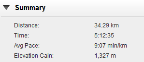
The Mount Lowry challenge consists of two events, The Bridgedale classic mountain trail run (11km) & the Vasque Extreme challenge (22km) mountain run with about 1000m of height gain on the course, the Extreme challenge was limited to only 50 participants. I entered the Vasque Extreme event & this is how it went. This event is known for it’s hilly terrain & has it’s own legendary status because of champion mountain runners Melissa Moon & James Coubrough.
The event location is about 30mins drive from where I live in a small sea side town called Eastbourne in Wellington, New Zealand. My event was scheduled for 8:30am with registration & race number pickup from 7:30am. I got there around 7:45am to pick up my number & check in. There were a few of my buddies from Wellington Running Meet up group who were doing the event as well. So I had some company to have a bit of pre-race banter.

Buddies from Wellington Running Meetup. – Kathy, Me, Dom and Ash
There is a great community feel to the event because it’s locally operated, they even have special prices for local participants. The event HQ was in a little park so there was plenty of people gathered to cheer the runners.

Start of Mt Lowry Extreme Challenge
We had a race briefing at 8:15am then we were off at 8:30am sharp. I felt pretty good going ino the race, no sign of any niggles & I’ve been running pretty well for the last three weeks as part of my overall 16 week marathon training plan. This was an event I wanted to use to get some decent hill climbs into my schedule. My goal was to run most of the hills & try to run the 22km under 2hrs 45mins which was achievable in my mind.
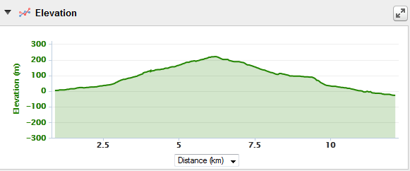
The first 3km was pretty flat along the coastal road to the start of the trail head. I eased into a steady pace without pushing it too much around 4:30 per Km. From the start of the trail it climbs steadily for about 200m straight up, I was doing well around 6:00 per Km up to about 2km into the climb & then my legs just felt completely dead, like someone just hung two 100kg dumb bells to them & my calves were hurting like hell! This took me completely by surprise, I’ve run enough hills & never had this effect before! I was reduced to a painful but steady walk & about 4 people passed me, I was a bit mentally drained but just kept power walking up the hill. It was a painful climb but eventually got to the top. Stopped at the top & did some stretches, the pain was still there but since I was at the top, the trail evened out to being flat so I started a slow run. Eventually the heavy feeling on my legs subsided & I was able to run the next bit but much slower than I anticipated. At this point I realised I needed to forget about my time goal of 2hrs 45, ain’t going to happen!
Around the 6km mark is another steady climb, it wasn’t easy but I went on & in a weird way I was getting used to the pain & the heavy felling was getting lesser. The next 3km is along the top of the trig with a narrow trail which is full of tree roots, you had to watch every step but it was runnable. There was a cut off time at the halfway point at 11km where if you didn’t make it within 1hr 45 you get pulled off the event. I made the 11k point in about 1hr 30.
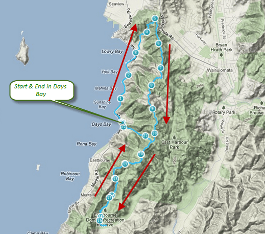
Mt Lowry Trail Map of the course
From the 11km point you entered into a forest where you had to pay very close attention to the trail as it descended steadily to the turn around point. This 2km stretch was a nightmare! You had to look up to check if you could spot the trail markers on the trees & you had to watch your step below as the trail was so overgrown & uneven with tree roots! Not fun! For a while I thought I was completely lost! And wait you had to do this bit twice as the route doubled back on the same trail to the turn off point. A few of the fast runners were on the way back including a couple of my buddies.
Anyways after this bit you come out of the forest into a well graded trail which descends rapidly. Uh oh – what goes down must come up! Essentially the trail drops from 300m to 50m & then you go back up the way you came again!

Mt Lowry Elevation Profile
The turnaround point was at around 15.5k where they record your number. Then you go back along the same up 300m! Just at around 16km as I was heading back two runners was coming down fast & me being the considerate runner took one side step to give them way & the next minute I was face down on the trail! $&@k & some other choice words followed! I think my ego was more hurt than any of my body parts as I took check of the damage! Arms OK! Knees.. Uh oh left knee was gushing blood but there was no pain! There was a piece of flesh hanging out but surprisingly no pain! I used my sweat band to wipe the blood away & continued on! A bit angry at myself but happy I hadn’t done too much damage, it’s just a wound & it will heal! Right climb up again & negotiate that forest bit then it’s a downhill! Quick look at my watch I knew I was way off my time I’d make 3:15 if I just keep moving! The last descent is just straight down & there was no way I was taking any chances so it was a slow descent to the bottom & into the finish line! Final time 3hrs 17mins.

Mt Lowry Garmin Summary
Usually after a race I haven’t done before I look forward to giving it another try, but this one I’m not so sure. Maybe after a few months I’ll feel differently. 🙂
Mount Lowry isn’t an easy challenge & it’s named the Extreme Challenge for a reason & today it owned me! I am however glad I took part! My knee is all good and wrapped up in dressing so nothing major. Next event is another mountain run – The Porirua Grand Traverse on the 7th of April!

At the Finish – all smiles despite how it all went! Patrick, Nicole, Me, Kathy, Lilla and Ash